I'll be setting off for a short tour of Britanny in a couple of weeks time. I'm wondering which map to buy. I'm considering the Michelin and the AA road maps. Any recommendations would be much appreciated.
Thank you.
Which maps for Britanny?
-
simonineaston

- Posts: 8077
- Joined: 9 May 2007, 1:06pm
- Location: ...at a cricket ground
Re: Which maps for Britanny?
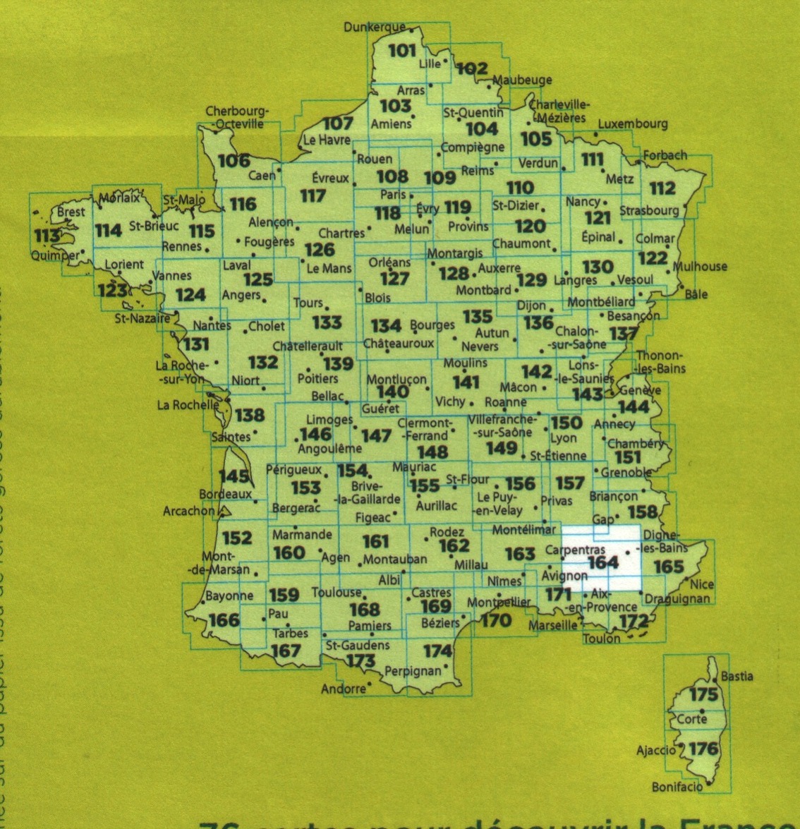
I'd need a bit more info. from you before I commit, like how far you're going and what you need to see on the map. For example, Michelin maps show the campsites they recommend, which will be of no interest to you if you're staying in chambres d'ote or hotels. I'm off to Gourarec where I will be doing 'star tours', and then going up to Paimpol for the music festival, so I'm taking the IGN Top 100 #114, which covers everywhere I'm going on this trip - lucky me!
Others will recommend smaller scale maps - the Michelin 'local' maps at 1:150k are popular.
Others will recommend smaller scale maps - the Michelin 'local' maps at 1:150k are popular.
S
(on the look out for Armageddon, on board a Brompton nano & ever-changing Moultons)
(on the look out for Armageddon, on board a Brompton nano & ever-changing Moultons)
Re: Which maps for Britanny?
Only the sites that wre in their guide the year the map was published. So probably about 5% of the available sites.simonineaston wrote:Michelin maps show the campsites they recommend
I use very minor roads and like to know just where I am. Hence I favour IGN TOP100 maps. They are 1:100,000 (close to the old Bartholomew's half inch maps we old ones remember) which means I can use forest tracks and all sorts. Index sheet here http://www.themapshop.co.uk/images/Fran ... 20100k.jpg
Re: Which maps for Britanny?
simonineaston wrote:I'd need a bit more info. from you before I commit, like how far you're going and what you need to see on the map. For example, Michelin maps show the campsites they recommend, which will be of no interest to you if you're staying in chambres d'ote or hotels. I'm off to Gourarec where I will be doing 'star tours', and then going up to Paimpol for the music festival, so I'm taking the IGN Top 100 #114, which covers everywhere I'm going on this trip - lucky me!
Others will recommend smaller scale maps - the Michelin 'local' maps at 1:150k are popular.
Thank for the reply. I'll be doing a small circuit from Roscoff over 6 days, staying in hotels. I'd like a map that shows the most minor roads and it would be nice if it indicated places of interest too......
Re: Which maps for Britanny?
tatanab wrote:Only the sites that wre in their guide the year the map was published. So probably about 5% of the available sites.simonineaston wrote:Michelin maps show the campsites they recommend
I use very minor roads and like to know just where I am. Hence I favour IGN TOP100 maps. They are 1:100,000 (close to the old Bartholomew's half inch maps we old ones remember) which means I can use forest tracks and all sorts. Index sheet here http://www.themapshop.co.uk/images/Fran ... 20100k.jpg
I like the look of the IGN TOP 100 map - number 114. It seems to show contour lines, which I haven't seen in the AA or Michelin maps. I think that might be the one to go for....
Thanks for the suggestion.

Re: Which maps for Britanny?
tatanab wrote:Only the sites that wre in their guide the year the map was published. So probably about 5% of the available sites.simonineaston wrote:Michelin maps show the campsites they recommend
Michelin stopped showing campsites several years ago (maybe 8 or 10?).
I gave up on Michelin and swapped to IGN Top 100, when they gave up on uniform sheet coverage and switched to departmental maps at random scales
-
simonineaston
- Posts: 8077
- Joined: 9 May 2007, 1:06pm
- Location: ...at a cricket ground
Re: Which maps for Britanny?
Yes, the Top 100 are my favourite too - I always used to think 'Top' meant they're The Best, but actually it's short for Topographical.  I take the paper jobbie to augment the IGN 1:100K mapping I have on the Satmap. The combo works well 'cos I'm looking at the same map style on both versions. I've nearly always identified campsites and other points of interest ahead of time and marked them as such on the Satmap. Having this combination is a luxury, I know, but of course anyone can join the club for a few Euros - although to protect the paper version, I would recommend one of the cheapNcheerful water-proof PVC multi-purpose pouches you can get for next to nothing off of eBay. They come in sets of 3 and I've found them all v. useful in sometimes-rainy Brittany!
http://www.ebay.co.uk/itm/3-X-Waterproo ... 2c9af95be9
http://www.ebay.co.uk/itm/3-X-Waterproo ... 2c9af95be9
S
(on the look out for Armageddon, on board a Brompton nano & ever-changing Moultons)
(on the look out for Armageddon, on board a Brompton nano & ever-changing Moultons)
-
Merry_Wanderer
- Posts: 1002
- Joined: 31 Aug 2012, 9:33am
- Location: North Leicestershire
Re: Which maps for Britanny?
Mrs M_W and I have just returned from Normandy where we did day rides from our caravan. I would recommend the green cover IGN Top 100 at 1 : 100,000 scale. They show the quiet minor roads, Voie vertes and contour lines. Very useful. I bought 3 maps in Tabac shops at €7.75 euros each which at 1.43 euros per £ are good value